Big Sur Travel Guide: 11 Best Stops on Highway 1 (2026 + Map)
Big Sur is one of the most dramatic coastal drives in California. Highway 1 clings to cliffs 1,000 feet above the Pacific, the ocean is too cold and rough for swimming, and most of the stops are short scenic pulls where you get out, look at something extraordinary, and get back in the car. It is not a beach destination. It is a spectacle destination, and the spectacle is consistent for 90 miles.
I have driven Highway 1 through Big Sur multiple times and the route never gets old. In fact, it gets better as you learn where to stop and when. The stretch from Carmel south to San Simeon takes 2–3 hours of pure driving without stops. With stops, plan for a full day minimum. and ideally spend the night somewhere in the middle.
Road conditions warning: Always check Highway 1 conditions before driving Big Sur. Rockslides and storm damage close sections of the road with no notice, sometimes for months. Check current conditions at dot.ca.gov (Caltrans) before your trip.
This post contains affiliate links. If you book through one of my links, I may earn a small commission at no extra cost to you.
11 Best Stops in Big Sur
Listed north to south as you drive from Carmel. This is the order to follow.
1. Point Lobos State Natural Reserve
Point Lobos is technically just north of Big Sur, at the very start of the route, but it is the best park on the entire stretch and the right way to begin the drive south. I have been to a lot of California state parks and Point Lobos is the one I recommend most consistently. the combination of accessible trails, wildlife, and genuinely turquoise water is hard to match anywhere else on the coast.
The reserve has coastal trails through Monterey cypress forests, turquoise coves that look impossibly blue against the grey rock, sea otters floating in the kelp beds just offshore, and sea lions hauled out on the rocks at Sea Lion Point. The Allan Memorial Grove has some of the oldest Monterey Cypress trees in the world. The Bird Island Trail (0.8 miles) and the South Shore Trail (1 mile) are both easy and deliver consistent views of the coves and the open Pacific.
The parking lot fills by 8am on summer weekends. Either arrive before 8am or park outside on Highway 1 and walk in. $2 per person instead of $10 parking fee if you walk in from outside, which is a genuinely good deal.
$10 parking per vehicle. 62 Highway 1, Carmel.
Book the Point Lobos Kayak Tour to see the sea caves and sea otters from the water. From $60 per person.
2. Garrapata Bluff Trail
About 7 miles south of Carmel on Highway 1. The Garrapata Bluff Trail runs along the cliff edge above the Pacific for about 2 miles. Sweeping ocean views in every direction, the crashing surf far below, and wildflowers. including the famous Calla Lily Valley. in spring. Additionally, this stretch of coast sees whale migrations from December through May, and the bluff is an excellent viewing point.
Park at the small pullout on the west side of Highway 1 near post marker 13.0. The trail starts from the gate.
Free. Highway 1, approximately 7 miles south of Carmel.
3. Calla Lily Valley at Garrapata Beach
Just past Garrapata Bluff, a short trail leads down to Garrapata Beach where the Calla Lily Valley sits in a fold of the hillside. From January through April, wild white calla lilies cover the valley floor in a way that looks curated but is entirely natural. It is one of the most surprising and beautiful seasonal stops on the entire highway.
Walk down to the beach (steep trail, about 10 minutes) and follow the stream into the valley. Free. Unmarked trailhead on Highway 1.
4. Bixby Creek Bridge
Bixby Creek Bridge is the most photographed bridge in California and one of the most photographed bridges in the world. A 714-foot concrete arch spanning a deep canyon with the Pacific behind it, built in 1932 by workers who were largely hanging from ropes above a 260-foot drop. The engineering story is as impressive as the view.
Pull into the north turnout before the bridge for the classic angle. the full span of the arch with the canyon below and the ocean visible in the background. The south turnout gives a closer view of the arch. Both are worth stopping at.
Free. Highway 1, approximately 13 miles south of Carmel. North turnout just before the bridge, south turnout just after.
5. Andrew Molera State Park
Andrew Molera is the first large state park in the Big Sur area and the access point for the best beach walking in the region. The Beach Trail (2 miles round trip) leads through meadows and riverside forest to a long driftwood-strewn beach at the mouth of the Big Sur River. The river walk itself is beautiful in its own right, particularly in autumn when the sycamores turn gold.
Additionally, the park has the best camping in Big Sur. walk-in sites right on the bluff above the ocean. Reserve far in advance.
$10 per vehicle. Highway 1, approximately 21 miles south of Carmel.
6. Pfeiffer Big Sur State Park
Pfeiffer Big Sur is the main hub of the Big Sur area. the park with the most facilities, the largest campground, and easy access to the redwood forest and the Big Sur River. The Pfeiffer Falls Trail (1.6 miles round trip) leads through old-growth coastal redwoods to a 60-foot waterfall, and in spring the forest floor is covered in clover and ferns. It is a completely different landscape from the coastal cliffs and deserves at least an hour.
$12 per vehicle. 47225 Highway 1, Big Sur.
7. Pfeiffer Beach
Pfeiffer Beach has purple sand. manganese garnet washed down from the Pfeiffer Ridge mountains. and a sea arch at the north end that the Pacific pours through at high tide. It is one of the most distinctive beaches in California and most visitors drive right past it because the turnoff is deliberately unmarked.
The turnoff is Sycamore Canyon Road on the right side of Highway 1, 0.4 miles south of Big Sur Station. There is a small sign but it is easy to miss. The road is narrow and unpaved for 2 miles.
$15 parking. Sycamore Canyon Road off Highway 1.
8. Nepenthe Restaurant
Nepenthe at mile marker 48.9 has a terrace 808 feet above the Pacific and is the lunch stop I never skip on Big Sur. The restaurant has been here since 1949 and the view from the terrace is one of the most expansive on the entire coast. the cliffs and ocean stretching in both directions as far as you can see.
The Ambrosia burger is the move for lunch. Around $22–28. The wine is overpriced. The view is not.
Around $25–45 for lunch. 48510 Highway 1, Big Sur.
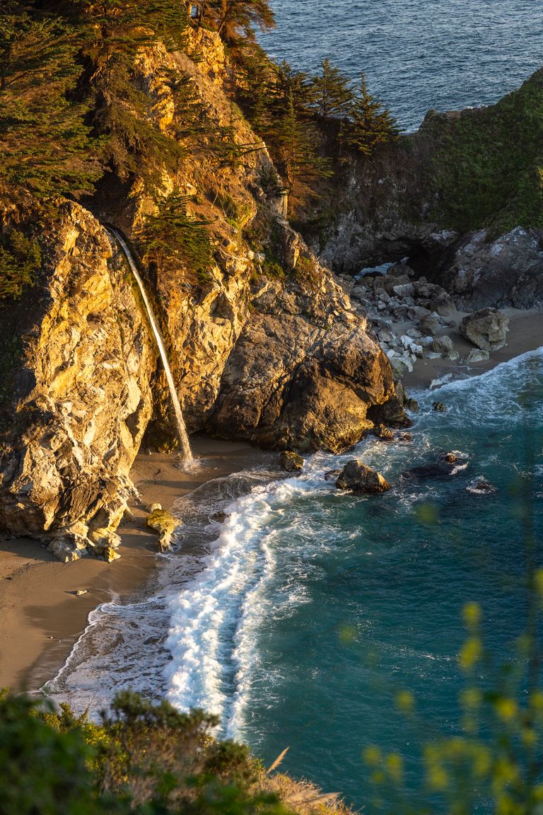
9. Julia Pfeiffer Burns State Park and McWay Falls
McWay Falls drops 80 feet directly onto a beach cove below that you cannot access. The viewpoint is a short flat walk from the day use parking area. about 10 minutes return. The waterfall, the turquoise cove, and the Pacific behind it is the most reproduced image in Big Sur and it fully earns that status.
The viewpoint path goes through a short tunnel under Highway 1 and emerges on the cliff above the cove. Free with day use parking. The photo stop is worth every moment.
$12 day use per vehicle. Highway 1, approximately 37 miles south of Carmel.
10. Partington Cove
Partington Cove is the Big Sur stop that most visitors skip and that I always make time for. A short trail (1 mile round trip) drops through a tunnel hand-dug into the coastal rock in the 1880s, emerging at a dramatic sea cove where the Pacific surges through a narrow rocky inlet. The cove is accessible only at this spot and the combination of the tunnel, the surging water, and the vertical cliffs around it makes it feel genuinely remote even though it is right off the highway.
Free. Unmarked trailhead on the west side of Highway 1, approximately 2 miles north of Julia Pfeiffer Burns State Park.
11. Elephant Seal Vista Point at Piedras Blancas
About 2 hours south of the main Big Sur stretch, just north of San Simeon, the Piedras Blancas elephant seal rookery is right on Highway 1 with viewing platforms directly above the beach. Hundreds to thousands of elephant seals depending on the season. the largest males weigh up to 5,000 pounds and the colony is audible from the parking area.
The colony is most dramatic from December through March during pupping season. However, seals are present year-round and free to view from the platforms any time.
Free. Highway 1, approximately 5 miles north of San Simeon.
Where To Eat in Big Sur
Nepenthe (mile marker 48.9) is the best lunch stop on the highway. The view alone is worth the price. The Ambrosia burger is consistently excellent. Around $25–45.
Big Sur Bakery on Pheneger Creek Road makes excellent wood-fired pizzas and pastries. One of the few good food options that is not astronomically priced for the location. Around $15–25.
Deetjen’s Big Sur Inn restaurant is the best dinner option in the area. a 1930s redwood restaurant with a menu that changes with the seasons. Around $35–60 per person. Reserve ahead.
Rocky Point Restaurant (12 miles south of Carmel) has the most dramatic dining view on the highway. glass walls looking directly at the ocean. Lunch around $25–35.
Where To Stay in Big Sur
Big Sur accommodation books up months ahead in peak season. Book before you commit to dates.
Post Ranch Inn is the most famous property in Big Sur. cliffside cabins with floor-to-ceiling windows looking over the Pacific. From $900+/night and worth every dollar if it is within budget.
Ventana Big Sur is the more accessible luxury option. hillside cottages with ocean views, pool, and spa. From $600–900/night.
Deetjen’s Big Sur Inn is the most characterful budget-friendly option. a 1930s Norwegian-style inn in a redwood canyon. From $150–250/night.
Camping: Pfeiffer Big Sur State Park and Andrew Molera have the best campgrounds. Both require advance reservations at reservecalifornia.com.
Best Time To Visit Big Sur
April to June is the best window. Waterfalls are at peak flow from winter rains, the hillsides are green, wildflowers cover the bluffs, and the Calla Lily Valley at Garrapata is in full bloom. Additionally, whale watching from the bluff trails is excellent through May.
September to October is the second-best time. The summer fog clears, the light on the cliffs is the sharpest of the year, and the tourist crowds thin significantly after Labor Day.
June to August is peak season. The marine layer sits over the coast most mornings, often clearing by noon. The highway is at its most congested. Still beautiful, just plan morning activities for afternoons.
November to March is quieter and cheaper. Some businesses close or reduce hours. However, the storm-watching from the bluffs in winter. when large Pacific swells hit the cliffs. is one of the most dramatic coastal experiences available in California.
How To Drive Highway 1 Through Big Sur
Drive south. North to south on Highway 1 puts you on the ocean side of the road. The pullouts are on your right where you want them, you can see the water easily from the driver’s seat, and the afternoon light falls on the cliffs from the west.
Fill up in Carmel. The next reliable gas stations going south are in Cambria near San Simeon. about 2 hours down the coast. Some stations exist in Big Sur but they are expensive. Always start with a full tank.
Download offline maps. Cell service is zero through most of Big Sur. Google Maps offline downloaded before leaving Carmel is essential.
Check Caltrans before every Big Sur day. dot.ca.gov. Rockslides close Highway 1 seasonally without advance warning. Five minutes checking the site can save hours of frustration from an unexpected inland detour.
How To Get To Big Sur
From San Francisco: 3 hours south to Carmel, then Highway 1 south into Big Sur.
From Los Angeles: 5 hours north on Highway 101 to San Luis Obispo, then Highway 1 north through Morro Bay and San Simeon to Big Sur.
From Monterey: 45 minutes south on Highway 1 from Monterey to the start of the main Big Sur stretch.
Big Sur Travel Guide Map
[EMBED: Google Map with all 11 stops pinned in route order, north to south]
Save this guide for your Big Sur road trip.
More California coast: Pacific Coast Highway Road Trip · Monterey and Carmel Travel Guide · West Coast USA Road Trip Guide