West Coast USA Road Trip: The Complete Guide (12 Stops + Map)
If someone asked me for the one road trip to do in the United States, it would be this one. Not because it is the easiest or the most straightforward, but because it is the most complete. In 12 stops and roughly 3,000 miles, this West Coast USA road trip covers the California coast, the best city in the Southwest, four national parks that look nothing alike, and two national park clusters that between them contain some of the tallest trees and most dramatic mountain scenery in North America.
I have driven this loop in both directions. It works perfectly either way. This guide follows the route starting from San Francisco heading south. which I prefer because driving Highway 1 south puts you on the ocean side of the road, making it easier to pull over and actually see the water.
This post contains affiliate links. If you book through one of my links, I may earn a small commission at no extra cost to you.
Table of Contents
- West Coast Road Trip Quick Facts
- The Full Route Overview
- Stop by Stop: The Full West Coast Loop
- Stop 1: San Francisco
- Stop 2: Monterey and Carmel
- Stop 3: Big Sur
- Stop 4: Los Angeles
- Stop 5: Las Vegas
- Stop 6: Zion National Park
- Stop 7: Bryce Canyon National Park
- Stop 8: Page, Arizona
- Stop 9: Grand Canyon South Rim
- Stop 10: Death Valley National Park
- Stop 11: Sequoia and Kings Canyon
- Stop 12: Yosemite National Park
- Road Trip Tips
- Best Time for the West Coast Road Trip
- How Long Do You Need?
- West Coast Road Trip Map
West Coast Road Trip Quick Facts {#quick-facts}
Start and end: San Francisco (loop. works in both directions).
Total distance: Approximately 3,000 miles.
Recommended days: 21–28 days. Minimum 18 days to do the loop without feeling rushed.
America the Beautiful Pass ($80): Covers entry to Zion, Bryce Canyon, Grand Canyon, Death Valley, Sequoia, Kings Canyon, and Yosemite. Individual entry to those seven parks costs $245+. Buy at the first park you visit or at store.usgs.gov. This is non-negotiable for this trip.
Car rental: Compare at Discover Cars. Pick up and drop off in San Francisco.
Book ahead: Alcatraz (San Francisco), Antelope Canyon guided tours (Page), Angels Landing permit (Zion), Yosemite day-use reservation (peak season, late May–early September).
Best season: April to May or September to October.
The Full Route Overview
San Francisco → Monterey and Carmel (2 hrs) → Big Sur (1 hr from Carmel) → Los Angeles (3.5 hrs from Big Sur) → Las Vegas (4.5 hrs from LA) → Zion NP (2.5 hrs from Vegas) → Bryce Canyon (1.5 hrs from Zion) → Page AZ (2.5 hrs from Bryce) → Grand Canyon (2.5 hrs from Page) → Death Valley (4 hrs from Grand Canyon) → Sequoia and Kings Canyon (3 hrs from Death Valley) → Yosemite (2.5 hrs from Sequoia) → San Francisco (3.5 hrs from Yosemite)
One full loop. Works in both directions. Go south first for the best Highway 1 experience.
Stop by Stop: The Full West Coast Loop
Stop 1: San Francisco
Recommended days: 2–3 days.
Drive to next stop: 2 hours to Monterey.
San Francisco is the right city to start this road trip from. It has a walkable, explorable quality that LA and Las Vegas do not. you can spend two days here without a car, leave it parked at the hotel, and not feel like you are missing anything. Then pick it up for the drive south.
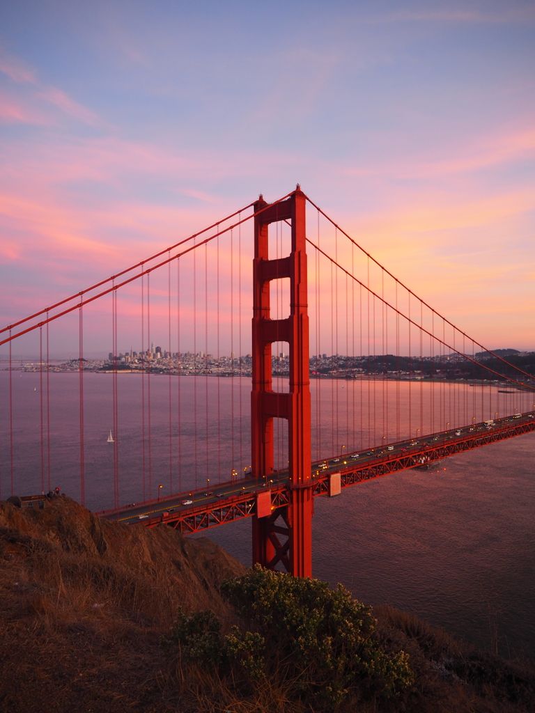
The Golden Gate Bridge from Battery Spencer in the Marin Headlands is the first morning. Alcatraz at night is the best thing to book ahead (alcatrazcitycruises.com, ~$60 for the night tour). The Painted Ladies at Alamo Square at golden hour. Twin Peaks for the sunset panorama. Lands End for the coastal walk and the Sutro Baths ruins.
The thing about San Francisco that I keep coming back to is that every neighborhood feels like a different city. The Mission has nothing in common with North Beach. North Beach has nothing in common with the Presidio. Three days is the minimum to feel like you have actually been here.
For the full San Francisco guide: San Francisco 3-Day Itinerary.
Key stops: Battery Spencer (GGB viewpoint), Alcatraz night tour, Painted Ladies, Twin Peaks, Lands End and Sutro Baths.
[IMAGE PLACEHOLDER: San Francisco Golden Gate Bridge Battery Spencer sunrise Marin Headlands West Coast road trip start]
Stop 2: Monterey and Carmel
Recommended days: 1–2 days.
Drive from SF: 2 hours south on Highway 101 or 2.5 hours scenic via Highway 1.
Monterey and Carmel are 10 minutes apart and both deserve time. I always combine them into one stop.
The Monterey Bay Aquarium is one of the best aquariums in the world. the Open Sea tank with bluefin tuna and ocean sunfish visible through a three-storey window is the anchor of the visit. ~$50 per person, book ahead.
17-Mile Drive through the Pebble Beach golf estate ($12.25 per vehicle) connects Monterey and Carmel via a private coastal road. The Lone Cypress. a single weathered cypress tree on a rock above the Pacific, one of the most photographed trees in California. is the main stop. Allow 1.5 hours with stops.
Point Lobos State Natural Reserve just south of Carmel is the best park on the Monterey Peninsula. Turquoise coves, sea otters in the kelp beds, coastal cypress trails. $10 parking, fills before 8am on weekends.
Carmel Beach at sunset is one of the most beautiful beach moments on the entire California coast. White sand, low cypress trees, and the Pacific turning orange.
Key stops: Monterey Bay Aquarium, 17-Mile Drive, Point Lobos, Carmel Beach.
[IMAGE PLACEHOLDER: Point Lobos State Natural Reserve Carmel California turquoise cove sea otters cypress trees]
Stop 3: Big Sur
Recommended days: 2 days.
Drive from Carmel: 1 hour south on Highway 1.
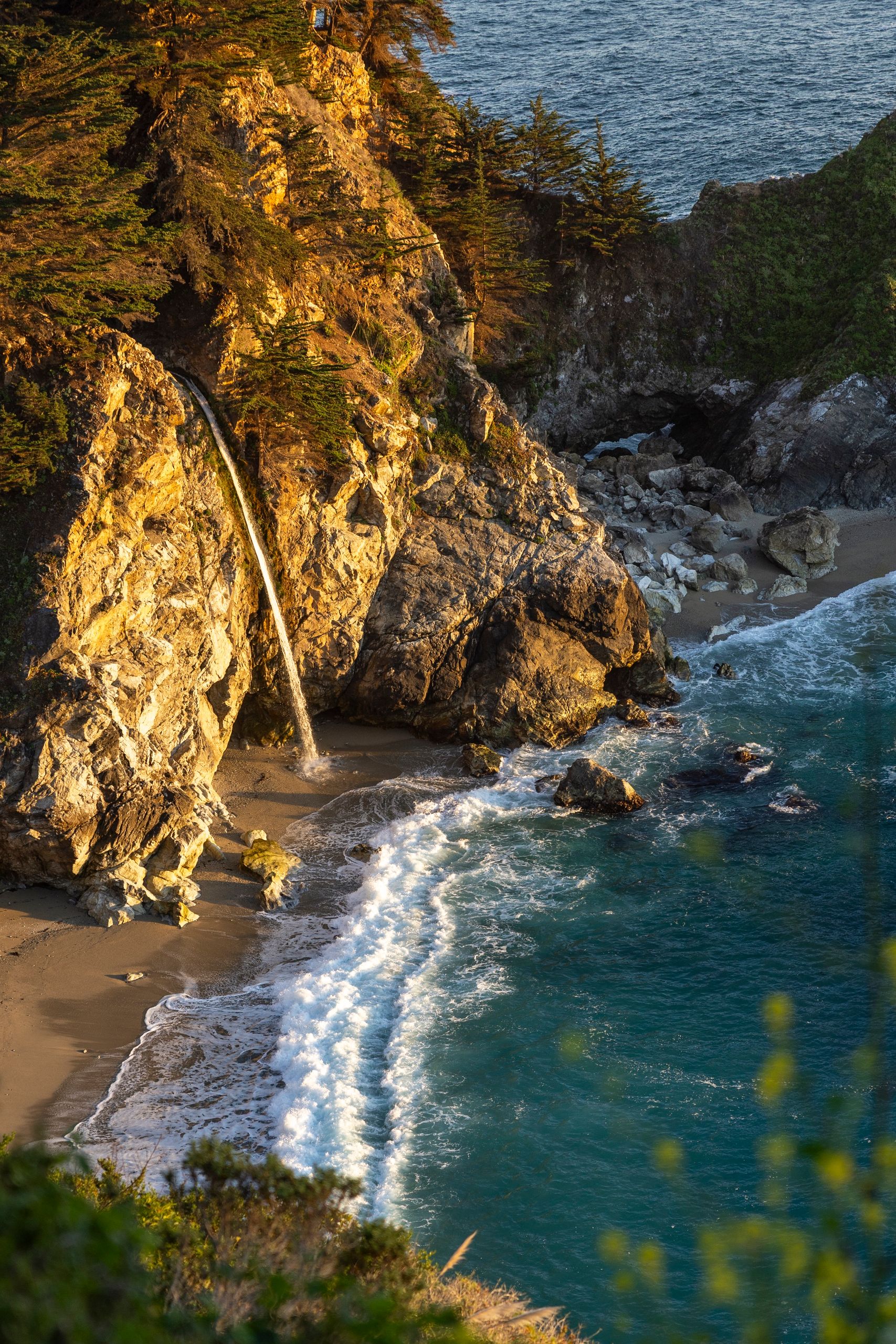
Big Sur is 90 miles of the most dramatic coastal driving in California. Highway 1 clings to cliffs 1,000 feet above the Pacific, there is no phone signal for most of the route, and most of the stops are short scenic pulls where you get out, look at something extraordinary, and keep moving.
Bixby Creek Bridge is the most photographed bridge in California. a 718-foot concrete arch spanning a deep canyon above the Pacific, built in 1932. Stop at the north pullout before the bridge for the classic angle.
McWay Falls at Julia Pfeiffer Burns State Park drops 80 feet directly onto a beach below that you cannot access. The vista point is a short flat walk from the car park. The waterfall, the cove, and the Pacific behind it is the most reproduced image in Big Sur.
Pfeiffer Beach has purple sand and a sea arch at the north end. The turnoff is unmarked. watch for Sycamore Canyon Road on the right, 0.4 miles south of Big Sur Station. $15 parking.
Always check dot.ca.gov (Caltrans) before driving Big Sur. Rockslides close sections of Highway 1 seasonally and with no advance warning.
For the full Big Sur guide: Big Sur Travel Guide.
Key stops: Bixby Creek Bridge, McWay Falls, Pfeiffer Beach, Point Lobos (already covered at Stop 2).
[IMAGE PLACEHOLDER: Big Sur Bixby Creek Bridge California Highway 1 ocean cliffs canyon coast]
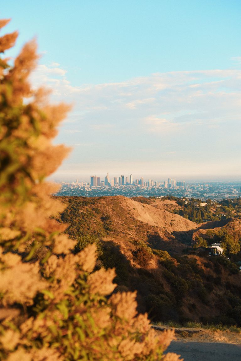
Stop 4: Los Angeles
Recommended days: 3 days.
Drive from Big Sur: 3.5 hours south on Highway 1 or Highway 101.
Los Angeles is the biggest stop on the route and deserves the time. The thing I had to learn about LA is to stop trying to see all of it and instead go deep into one or two neighborhoods per day. Once I did that, the city became genuinely enjoyable rather than exhausting.
Day 1: Hollywood and central LA. Walk of Fame, Academy Museum ($25), LACMA and Urban Light (free), Griffith Observatory at sunset (free).
Day 2: Downtown. The Broad Museum (free, book ahead), Bradbury Building (free), Grand Central Market for lunch ($15–20), Angel’s Flight ($1), The Last Bookstore (free).
Day 3: West side and beaches. Getty Center (free, $25 parking, book at getty.edu), Santa Monica Pier (free), Venice Beach Boardwalk (free), Venice Canals (free).
Tip: Do not drive across the city during rush hour (8–10am and 4–7pm). Plan each day’s stops geographically and move in one direction. Use Waze for real-time traffic routing.
For the full LA guide: Things To Do in Los Angeles.
Key stops: Griffith Observatory, The Broad Museum, Getty Center, Venice Canals.
[IMAGE PLACEHOLDER: Los Angeles Griffith Observatory city panorama sunset Hollywood Sign basin]
Stop 5: Las Vegas
Recommended days: 1–2 days.
Drive from LA: 4.5 hours east on I-15.
Las Vegas is the transition point between the California coast and the Southwest desert and it earns its place on this route as more than just a fuel stop. The Strip at night, the Bellagio Fountains, Fremont Street, Seven Magic Mountains in the desert outside town. there is genuinely enough here for two days.
I have come to appreciate Las Vegas more with each visit. The commitment to spectacle, the fact that some of the best things here are completely free, and the way the city sits in the middle of the Mojave like something that has no business existing. it is its own kind of extraordinary.
Detour: Seven Magic Mountains is 25 minutes south of the Strip on I-15. Neon coloured boulder stacks in the desert, free. My favourite stop in the Las Vegas area.
For the full Las Vegas guide: Things To Do in Las Vegas.
Key stops: Las Vegas Strip walk at night, Bellagio Fountains, Fremont Street, Seven Magic Mountains.
[IMAGE PLACEHOLDER: Las Vegas Strip night neon Bellagio fountains Nevada desert road trip West Coast]
Stop 6: Zion National Park
Recommended days: 2 days.
Drive from Las Vegas: 2.5 hours north on I-15 to Highway 9.
Zion was the national park that reset my sense of scale on my first Southwest trip. The canyon walls rise 2,000 feet on both sides of the Virgin River and the light that comes through in the morning turns the sandstone every shade of orange and gold.
The Narrows. walking up the Virgin River through the slot canyon. is the hike I recommend to everyone regardless of fitness level. No permit required. Start at the Temple of Sinawava (end of the canyon shuttle) and walk as far as the water and your energy allow. The first mile is extraordinary. The canyon walls narrow to 20 feet apart and the water moves cold and clear around your ankles.
Angels Landing requires a permit (lottery at recreation.gov, $6 + fee). Book months ahead for spring or fall. The final section involves chains bolted into the rock for handholds. not a technical climb but exposed. The view from the top is one of the best in the entire Southwest.
Canyon Overlook Trail (1 mile round trip) is the best easy hike with no permit and excellent canyon views. Good for sunrise.
Note: No private vehicles in the main canyon. Park at the Visitor Centre and take the free shuttle. Shuttle runs 7am–11pm during peak season.
Entry: $35/vehicle or America the Beautiful Pass.
Stay in Springdale. book months ahead for spring and fall.
[IMAGE PLACEHOLDER: Zion National Park Utah Canyon Overlook Trail sandstone walls Virgin River]
Stop 7: Bryce Canyon National Park
Recommended days: 1 day.
Drive from Zion: 1.5 hours east on Highway 9 to Highway 89.
Bryce Canyon is the most visually surprising park on this route. You arrive at the rim and look down into an amphitheatre filled with thousands of hoodoos. thin stone spires of red, orange, and white. and whatever you were expecting is immediately replaced by this.
Sunrise at Sunrise Point is the experience. The hoodoos glow red-orange in the first light and the amphitheatre fills from shadow slowly from the bottom up. I arrived before sunrise on a cold April morning and stayed for an hour without moving.
Navajo Loop and Queen’s Garden Trail (2.9 miles combined) drops into the amphitheatre and brings you through the hoodoos at ground level. Being inside them is completely different from looking down from the rim. Do this trail.
Inspiration Point gives the widest angle view of the whole Bryce Amphitheatre. short walk from the road, consistently excellent.
Entry: $35/vehicle or America the Beautiful Pass.
[IMAGE PLACEHOLDER: Bryce Canyon National Park Utah hoodoos sunrise orange red amphitheatre morning light]
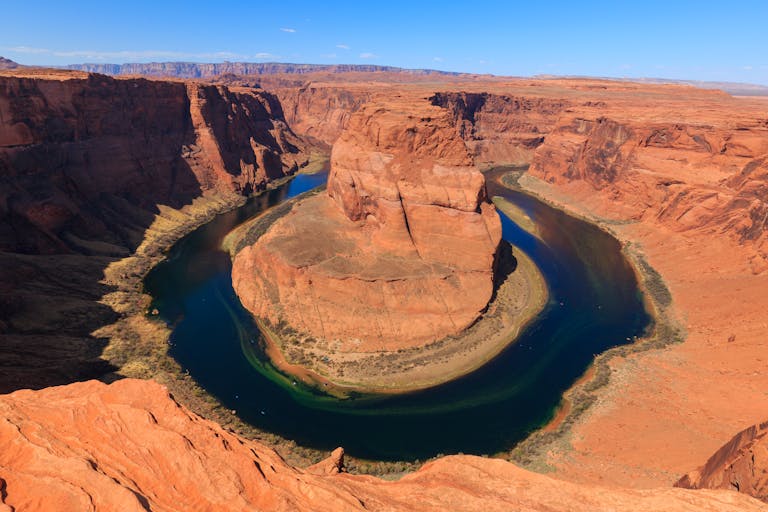
Stop 8: Page, Arizona
Recommended days: 1 day.
Drive from Bryce Canyon: 2.5 hours southeast on Highway 89.
Page has Antelope Canyon and Horseshoe Bend within 10 minutes of each other. Both are worth building a full day around.
Upper Antelope Canyon is a Navajo-guided slot canyon tour through walls of wave-shaped sandstone 120 feet deep and lit by shafts of light at midday. The most photographed slot canyon in the world. Book 3–4 weeks ahead minimum. Tours from $60–80 plus an $8 Navajo permit fee.
Horseshoe Bend is a 0.7-mile round trip walk to a viewpoint above a 1,000-foot cliff where the Colorado River makes a 270-degree bend around a sandstone mesa. Sunrise is the right time. soft light, fewer people, no direct sun causing contrast problems. $10 parking.
[IMAGE PLACEHOLDER: Horseshoe Bend Page Arizona Colorado River 270 degree sandstone cliff sunrise aerial view]
Stop 9: Grand Canyon South Rim
Recommended days: 1–2 days.
Drive from Page: 2.5 hours south on Highway 89 to Highway 64.
The Grand Canyon is the one stop on this route where I genuinely cannot convey the experience in words or photographs. You walk through the trees to the rim and then there is a mile-deep chasm in front of you and your brain simply has no framework for it. Every visit, no matter how many times I have been, that first moment at the rim is a recalibration.
Mather Point for the first look. South Kaibab Trail to Ooh-Aah Point (1.8 miles round trip) for the best view inside the canyon. no water on the trail, start early. Desert View Watchtower (25 miles east on the East Rim Drive) for the widest angle view from the South Rim. Hopi Point at sunset via the free shuttle for the evening light.
Do not attempt to hike to the Colorado River and back in one day. The Park Service posts signs about it and people ignore them every year. The climb back out in the afternoon heat is extremely dangerous.
Entry: $35/vehicle or America the Beautiful Pass.
[IMAGE PLACEHOLDER: Grand Canyon South Rim Arizona sunrise canyon walls Colorado River Mather Point]
Stop 10: Death Valley National Park
Recommended days: 1 day.
Drive from Grand Canyon: 4 hours northwest on Highway 93 to Highway 127.
Important: Only visit Death Valley from October to May. The average July high temperature is 116°F. This is not advisory. it is genuinely dangerous and people die here every summer.
Death Valley is the most otherworldly landscape on this entire road trip. The valley floor is 282 feet below sea level. the lowest point in North America. and surrounded by mountain ranges that trap the heat. The colours in the rock, the salt formations at Badwater Basin, and the scale of the valley are unlike anything else in California.
Dante’s View is a 5,476-foot overlook directly above Badwater Basin with a panoramic view of the full valley. Drive-up, completely free.
Zabriskie Point at golden hour. The eroded badlands glow gold, amber, and deep orange in the last hour before sunset. One of the best golden hour stops in the entire Southwest.
Badwater Basin is the salt flat at the lowest point in North America. Walk out onto the white salt and the valley walls rise 11,000 feet above you on the west side.
Artist’s Drive is a 9-mile one-way scenic loop through painted hills of pink, purple, green, and gold mineral deposits. Mid-afternoon light makes the colours most vivid.
Entry: $35/vehicle or America the Beautiful Pass.
[IMAGE PLACEHOLDER: Death Valley National Park Zabriskie Point golden hour badlands California desert sunset]
Stop 11: Sequoia and Kings Canyon National Parks
Recommended days: 2 days.
Drive from Death Valley: 3 hours northwest on Highway 190 to Highway 99 to Highway 180.
Sequoia resets your sense of scale again, this time vertically. Giant sequoias are the largest living organisms on Earth by volume and no photograph has ever prepared me for standing next to one. The General Sherman Tree. 274 feet tall, 102 feet in circumference at the base. is a 0.5-mile walk from the parking area. I have done this walk four or five times and still spend 10 minutes just looking up at it.
Congress Trail is a 2-mile loop through the grove. Early morning in the sequoia forest, when the light comes down through the canopy, is one of the most peaceful environments I have encountered anywhere in California.
Moro Rock is a granite dome you reach via 350 stone steps. 360-degree summit views of the Sierra Nevada. On a clear day you can see for 100 miles.
Kings Canyon Scenic Byway drops into one of the deepest canyons in North America with walls rising 8,000 feet. The drive alone is worth the detour. Open from late May through October.
Entry: $35/vehicle covers both Sequoia and Kings Canyon. America the Beautiful Pass.
[IMAGE PLACEHOLDER: Sequoia National Park California General Sherman Tree giant sequoia Congress Trail forest light]
Stop 12: Yosemite National Park
Recommended days: 3 days.
Drive from Sequoia: 2.5 hours north on Highway 41.
Yosemite is the final national park on the loop and the one that closes everything out perfectly. After the red rock and desert landscapes of the Southwest, the valley’s granite cliffs and waterfalls and green meadows hit completely differently.
Tunnel View on the drive in is the first stop. the classic Yosemite composition with El Capitan on the left, Bridalveil Fall on the right, and Half Dome straight ahead. I have seen this view dozens of times in photographs and it still stops me when I drive through the tunnel and the valley opens up.
Mist Trail to Vernal and Nevada Falls is the hike you come to Yosemite for. 8.5 miles round trip, 2,000 feet of elevation gain, 5–6 hours. The Vernal Fall spray zone soaks you completely. bring a waterproof case for your camera. Worth every wet step.
Glacier Point (seasonal, late May–November) is a 7,214-foot viewpoint looking directly at Half Dome with the valley floor 4,800 feet below. Best at sunset when the valley fills with shadow while the peaks stay lit.
Tip: Day-use vehicle reservation required on busy weekends in peak season (late May–early September, 6am–4pm). Check nps.gov/yose before your trip. Book at recreation.gov.
For the full Yosemite guide: Yosemite 3-Day Itinerary.
Entry: $35/vehicle or America the Beautiful Pass.
[IMAGE PLACEHOLDER: Yosemite National Park Tunnel View El Capitan Bridalveil Fall Half Dome valley California]
Road Trip Tips
America the Beautiful Pass ($80): Covers all seven national parks on this route. Individual entry: $245+. This is the single most important practical tip for anyone doing this road trip. Buy it.
Drive south first. Starting from San Francisco and driving south on Highway 1 puts you on the ocean side of the road. easier pullouts, better driver’s seat views, and the natural flow of stopping at Big Sur on the way to LA rather than doubling back. The route works both ways but south-first is the better version.
Book permits and tours early. Angels Landing lottery (Zion). apply months ahead. Antelope Canyon tours. book 3–4 weeks ahead in peak season. Yosemite day-use reservation. book when the reservation window opens. Alcatraz night tour. book 2+ weeks ahead.
Death Valley timing. October through May only. June through September is genuinely dangerous. If you are doing this trip in summer, either skip Death Valley entirely or replace it with an extra day in Sequoia.
Gas and cell service. Fill up in every town before entering the parks. Cell service drops out in Zion, Bryce, Death Valley, Sequoia, and Yosemite valley. Download offline maps on Google Maps for the full route before leaving San Francisco. Never drive through the Southwest on a quarter tank.
Car choice. A standard 2WD rental handles the entire core route. All the major viewpoints and parks are accessible on paved roads. The only exceptions are the dirt road sections of Monument Valley (if you add the Southwest extension) and some of the backcountry in Capitol Reef.
Best Time for the West Coast Road Trip
April to May is the best window. Yosemite waterfalls at peak flow, Zion and Bryce uncrowded, Death Valley safe, wildflowers along the California coast. Glacier Point Road in Yosemite may still be closed in early April. check nps.gov/yose for current conditions.
September to October is the second-best time. Summer crowds thin after Labor Day, the national parks are at their most manageable, fall colour appears at Bryce Canyon, and the weather across the Southwest cools to pleasant levels.
June to August is possible but challenging. Death Valley is genuinely dangerous. Yosemite, Zion, and Bryce are at peak crowding. Start every day early and avoid the Southwest parks in the midday heat.
November to March is quieter and cheaper. Glacier Point Road (Yosemite) and Kings Canyon Road (Sequoia) close for winter. Death Valley is actually pleasant in winter temperatures. The California coast is green and uncrowded.
How Long Do You Need?
Minimum 18 days to complete the full loop without feeling rushed. That is roughly two days at each major stop.
21–28 days is the ideal range. Enough time to linger at Zion, spend a real afternoon in Bryce Canyon, and not feel like you are racing from park to park.
If you only have 2 weeks: Cut the Southwest loop and do a shorter California-focused version: San Francisco → Monterey and Big Sur → LA → Las Vegas (1 night) → Death Valley → Sequoia → Yosemite → San Francisco. Around 2,000 miles and 13–14 days.
West Coast Road Trip Map
[EMBED: Google Map with all 12 stops pinned in route order, full loop from San Francisco]
Save this guide for your West Coast USA road trip.
For each stop in detail: San Francisco 3-Day Itinerary · Big Sur Travel Guide · Things To Do in Los Angeles · Things To Do in Las Vegas · Yosemite 3-Day Itinerary · Southwest USA Road Trip