Southwest USA Road Trip Itinerary: 9–14 Days from Las Vegas (2026 Guide + Map)
The Southwest USA road trip was the trip that changed how I think about the United States. I had seen cities and coastlines, but nothing prepares you for the first time you drive into red rock country. the scale of the canyon walls, the silence of the desert, the light on the formations at golden hour. It is a completely different side of America from anything I had seen before.
I did this 9-day Southwest road trip itinerary and it is still one of the best trips I have ever taken. It starts and ends in Las Vegas, covers four states, and passes through some of the most extraordinary landscapes on Earth. This guide has everything you need to drive it yourself.
Table of Contents
- Southwest Road Trip Quick Facts
- Southwest USA Road Trip Route Overview
- Stop by Stop: The Full Itinerary
- Stop 1: Valley of Fire State Park
- Stop 2: Zion National Park
- Stop 3: Bryce Canyon National Park
- Stop 4: Capitol Reef National Park
- Stop 5: Monument Valley
- Stop 6: Page, Arizona
- Stop 7: Grand Canyon National Park
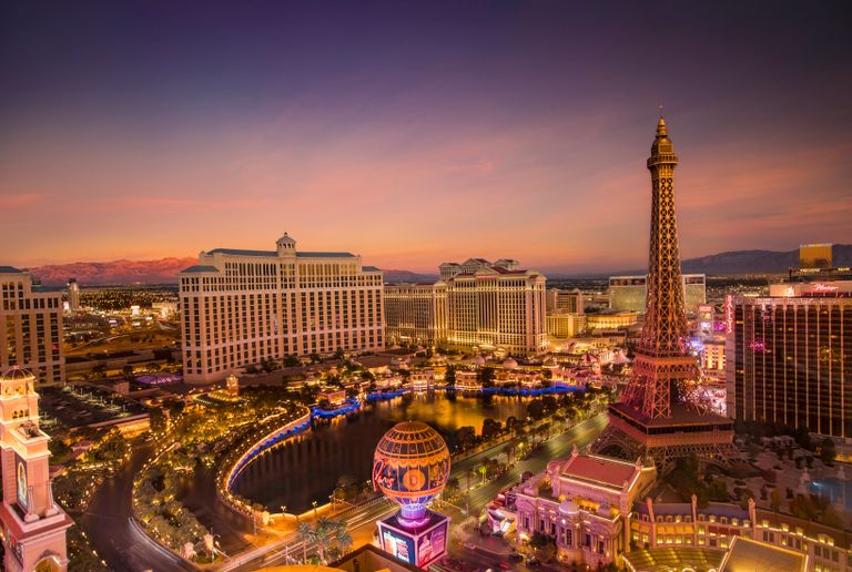
- Stop 8: Las Vegas
- Extended Route (Add-Ons)
- Southwest Road Trip Tips
- Best Time for the Southwest Road Trip
- Southwest USA Road Trip Map
Southwest Road Trip Quick Facts {#quick-facts}
Start and end: Las Vegas, Nevada.
Total distance: Approximately 1,500–1,800 miles depending on route.
Recommended days: 9 days minimum. 12–14 days ideal.
Highlights: Valley of Fire, Zion National Park, Bryce Canyon, Capitol Reef, Monument Valley, Antelope Canyon, Horseshoe Bend, Grand Canyon South Rim.
Park entry: $35 per vehicle for each national park. The America the Beautiful Annual Pass ($80) covers all national parks and federal lands for 12 months. it pays for itself after the first two parks on this route. Buy at the first park you visit or at store.usgs.gov.
Book ahead: Angels Landing permit (Zion). lottery at recreation.gov. Antelope Canyon (Page). guided tour required, book 2–4 weeks in advance. Yosemite day-use reservation if adding Yosemite to the route.
Best season: March to May or September to November.
This post contains affiliate links. If you book through one of my links, I may earn a small commission at no extra cost to you.
Southwest USA Road Trip Route Overview {#route-overview}
The core loop covers eight stops in roughly this order:
Las Vegas → Valley of Fire (1 hr) → Zion NP (2.5 hrs from Vegas) → Bryce Canyon (1.5 hrs from Zion) → Capitol Reef (2.5 hrs from Bryce) → Monument Valley (2 hrs from Capitol Reef) → Page, Arizona (1.5 hrs from Monument Valley) → Grand Canyon South Rim (2.5 hrs from Page) → Las Vegas (4 hrs from Grand Canyon)
Total driving: approximately 1,500 miles.
You can drive this loop in either direction. Going clockwise (as above, Valley of Fire first) is slightly more logical because it puts the most dramatic stops later in the trip and you see the Grand Canyon fresh before returning to Vegas.
Stop by Stop: The Full Itinerary {#stops}
Stop 1: Valley of Fire State Park {#valley-of-fire}
Drive from Las Vegas: 1 hour northeast on I-15 and Highway 169.
Recommended time: Half day to full day.
Start the road trip here rather than driving straight to Zion. Valley of Fire is 1 hour from Las Vegas and one of the most dramatic desert landscapes in the Southwest. ancient red sandstone formations, petroglyphs left by the Ancestral Puebloans 3,000 years ago, and a scale that the photographs genuinely cannot convey.
The Fire Wave is the most photographed spot in the park: layered red, pink, and white sandstone swirling together into patterns that look carved by a sculptor rather than shaped by wind and water over millions of years. Moderate 1.5-mile round trip trail. Go at golden hour when the formation glows red.
The Beehive Trail (3.5 miles) passes through a sequence of rounded sandstone domes. The Elephant Rock formation near the east entrance is a roadside stop that takes 10 minutes and photographs well in afternoon light. Rainbow Vista is a viewpoint overlooking the valley from above. short walk from the car park, consistently excellent.
Tip: Valley of Fire gets very hot in summer (110°F+). If you are visiting June through August, go to the park for sunrise and be back in the car by 10am.
$15 per vehicle (Nevada plates), $20 out-of-state. Free with America the Beautiful Pass.
Valley of Fire Highway, Overton, NV.
[IMAGE PLACEHOLDER: Valley of Fire State Park Nevada Fire Wave red sandstone swirling patterns desert Southwest road trip]
Stop 2: Zion National Park {#zion}
Drive from Valley of Fire: 1.5 hours north on I-15 to Highway 9.
Recommended time: 2 days.
Zion was the stop I was least prepared for on my first Southwest road trip. I knew the photos. The canyon is still bigger in person.
The park is a narrow canyon cut by the Virgin River through Navajo sandstone. the canyon walls rise 2,000 feet on both sides and the floor is a river you walk through. The scale is vertical in a way that most national parks are not.
No private vehicles in the main canyon. Park at the Visitor Centre and take the free shuttle. This is the right way to see the canyon. you get in and out where you want, there is no parking stress, and the shuttle ride itself is a good orientation.
The Narrows is the hike that defines Zion. You walk up the Virgin River through a slot canyon. the walls narrow to as little as 20 feet apart with the water running around your ankles and knees. No permit required. Start from the Temple of Sinawava at the end of the canyon shuttle route. Go as far as you want and turn back. The first mile is extraordinary. 5 miles is better. Bring water shoes or rent canyoneering boots from the outfitters in Springdale ($20–30).
Angels Landing is the most famous hike in Zion. a 5.4-mile round trip climb to a sandstone peak with 1,500-foot drops on both sides of the final ridge. The last section involves chains bolted into the rock for handhold. A permit is required ($6 + lottery fee) via recreation.gov. Apply months ahead for spring and fall. The permit lottery runs daily for walk-up spots too. check on the day you arrive.
Canyon Overlook Trail is 1 mile round trip with excellent canyon views and no permit required. Good for early morning or a warm-up hike.
Pa’rus Trail is a flat, paved 3.5-mile trail along the Virgin River. the best easy walk in the park and excellent for golden hour light on the canyon walls.
Entry: $35/vehicle or America the Beautiful Pass.
Base yourself in Springdale (just outside the park entrance). book accommodation months ahead for spring and fall.
[IMAGE PLACEHOLDER: Zion National Park Narrows slot canyon Virgin River Utah Southwest road trip hiking]
Stop 3: Bryce Canyon National Park {#bryce}
Drive from Zion: 1.5 hours east on Highway 9 and Highway 89.
Recommended time: 1 full day.
Bryce Canyon is not actually a canyon. it is a series of natural amphitheatres eroded into the Pink Cliffs, filled with hoodoos: tall, thin spires of red, orange, and white rock that look like a forest of stone pillars viewed from above.
I remember pulling up to Sunrise Point for the first time at sunrise and genuinely laughing. Not because it was funny, but because I had no other response to what was in front of me. Thousands of hoodoos glowing red and orange in the morning light, stretching as far as I could see. No photograph has ever prepared me for Bryce Canyon.
Sunrise Point and Sunset Point are the two main rim viewpoints. park the car and walk the 0.5-mile rim trail between them. The hoodoos are best lit at sunrise (at Sunrise Point, obviously) and in the late afternoon light.
Navajo Loop and Queen’s Garden Trail is the best hike in the park. A 2.9-mile loop that drops into the amphitheatre from Sunset Point, winds through the hoodoos at ground level, and climbs back out via Queen’s Garden. Moderate difficulty, 521 feet elevation change. Being inside the hoodoo forest at eye level is completely different from the rim view above.
Inspiration Point is the widest angle view of the Bryce Amphitheatre. accessible by a short trail from the road. Best in the morning.
Entry: $35/vehicle or America the Beautiful Pass.
Stay in Tropic (10 min south of the park entrance, cheaper) or Bryce Canyon Lodge inside the park (book well ahead).
[IMAGE PLACEHOLDER: Bryce Canyon National Park hoodoos sunrise orange red spires Utah amphitheatre Navajo Loop]
Stop 4: Capitol Reef National Park {#capitol-reef}
Drive from Bryce Canyon: 2.5 hours east on Highway 12 (one of the most scenic roads in the USA).
Recommended time: Half day to full day.
Highway 12 between Bryce Canyon and Capitol Reef is genuinely one of the most spectacular roads in the United States. It runs along the spine of a narrow ridge called the Hogsback with 1,000-foot drop-offs on both sides, crosses the Grand Staircase-Escalante National Monument, and gives you views of the Colorado Plateau that you cannot get from any other road. Do not rush this drive.
Capitol Reef is the least visited of the main Southwest parks and for that reason, one of the most peaceful. The Waterpocket Fold. a 100-mile long wrinkle in the Earth’s crust where rock layers were lifted and folded. runs the length of the park and creates a landscape of domes, cliffs, and narrow canyons unlike anything else on the route.
Hickman Bridge Trail is 1.7 miles round trip to a 133-foot natural sandstone arch. Easy, well-marked, and excellent views of the Capitol Dome.
Fruita Historic District has orchards planted by Mormon settlers in the 1880s that the park still maintains. In season (summer), visitors can pick cherries, apricots, and apples directly from the trees for a per-pound fee. I was not expecting this to be as charming as it is.
Panorama Point is a short drive from the visitor centre with a sweeping view of the Capitol Reef and the Henry Mountains.
Entry: $20/vehicle or America the Beautiful Pass.
[IMAGE PLACEHOLDER: Capitol Reef National Park Utah Hickman Bridge natural arch sandstone Waterpocket Fold]
Stop 5: Monument Valley {#monument-valley}
Drive from Capitol Reef: 2 hours south on Highway 24 and Highway 95 to Highway 163.
Recommended time: Half day to full day.
Monument Valley is the most cinematic landscape in America. The three Mittens and Merrick Butte rising from the valley floor have appeared in more films, television shows, and advertisements than any other natural landscape in the United States. John Ford shot Stagecoach here in 1939 and every director who came after him kept coming back.
Standing at John Ford’s Point. the overlook on the Valley Drive where most of those iconic shots were framed. and looking out at the Mittens is one of those moments where the real thing matches the image in your head. That almost never happens.
The 17-Mile Valley Drive is a dirt road loop through the monument with 11 viewpoints. Most vehicles can do it in a standard rental car but check conditions after rain. it becomes impassable in mud. The drive takes 2–3 hours with stops.
Forrest Gump Point (or Forrest Gump Hill) on Highway 163 a few miles before the Valley entrance is where the famous running scene was filmed. Stop on the road, look north at the valley spread out in front of you, and take the photo.
Note: Monument Valley is a Navajo Nation Tribal Park, not a federal park. Entry fee $20 per vehicle, paid directly to the Navajo Nation. The America the Beautiful Pass does not apply here.
$20 per vehicle (Navajo Nation fee). Guided tours from $70 per person.
Monument Valley Navajo Tribal Park, Utah/Arizona border.
[IMAGE PLACEHOLDER: Monument Valley Navajo Tribal Park Utah Arizona Mittens Merrick Butte red sandstone sunrise golden hour]
Stop 6: Page, Arizona {#page}
Drive from Monument Valley: 1.5 hours east on Highway 160 to Highway 98.
Recommended time: 1 day.
Page is the gateway to two of the most photographed natural features in the Southwest: Antelope Canyon and Horseshoe Bend. Both are within 10 minutes of the town centre. Both are extraordinary.
Upper Antelope Canyon is a slot canyon. a narrow passageway cut through Navajo sandstone by flash floods over thousands of years. The canyon is 120 feet deep in places and as little as 3 feet wide. At midday from April through October, light beams fall through the narrow opening above and illuminate columns of airborne dust, creating the shaft-of-light images that appear on every Southwest road trip mood board.
The canyon is on Navajo land and you must go with a licensed Navajo-run guided tour. Tours last about 1–1.5 hours. Book 3–4 weeks ahead minimum. it fills completely in peak season. The Upper Canyon is more accessible than the Lower Canyon; the Lower Canyon requires more physical agility but has fewer crowds.
Upper Antelope Canyon tour: from $60–80 per person, plus $8 Navajo land permit fee.
Book at: lakepowell.com or Ken’s Tours.
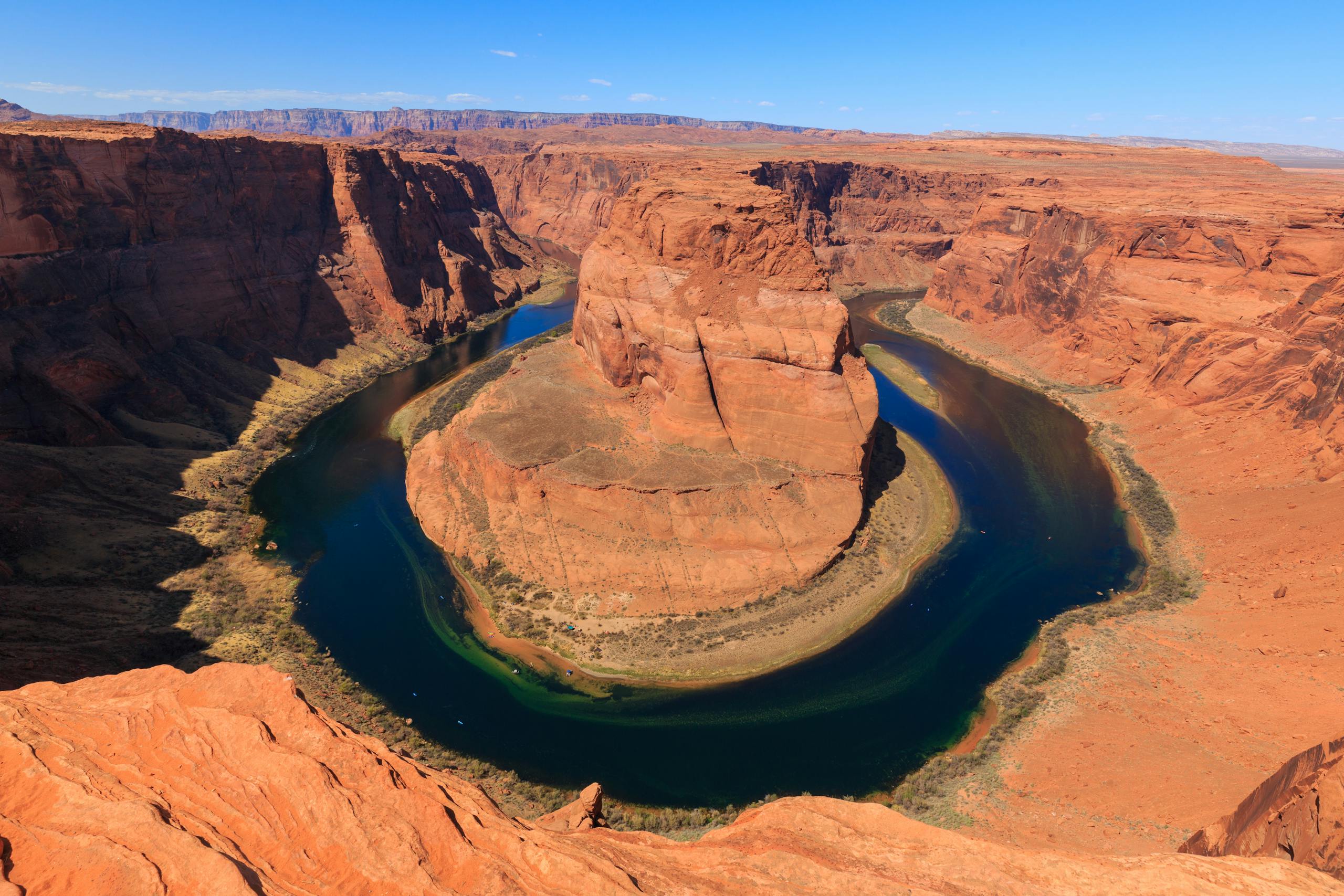
Horseshoe Bend is 5 miles south of Page off Highway 89. The Colorado River makes a 270-degree horseshoe bend around a 1,000-foot sandstone mesa. visible from a viewpoint at the top of the cliff. It is one of the most reproduced landscape photos in the American Southwest.
The walk from the parking area to the viewpoint is 0.7 miles round trip with 200 feet of elevation change through sand. Takes about 20 minutes. Go at sunrise for soft light and the fewest people. by 9am it is crowded.
$10 parking fee at Horseshoe Bend.
US-89, Page, AZ.
[IMAGE PLACEHOLDER: Antelope Canyon Page Arizona Navajo sandstone slot canyon light beams dust Upper Canyon]
[IMAGE PLACEHOLDER: Horseshoe Bend Page Arizona Colorado River 270 degree bend sandstone cliff sunrise]
Stop 7: Grand Canyon National Park {#grand-canyon}
Drive from Page: 2.5 hours south on Highway 89 to Highway 64.
Recommended time: 1–2 days.
I have been to the Grand Canyon multiple times and the first view from the rim still gets me every time. You park, you walk through the trees, and then suddenly there is a mile-deep hole in the Earth in front of you that your brain has no framework for. You know intellectually that it is 277 miles long and a mile deep. Standing at the rim, those numbers mean nothing. you just try to take in what your eyes are telling you.
Mather Point is the first major viewpoint from the South Rim Visitor Centre and the most visited. The canyon spreads in both directions from here. Excellent for a first look. Gets crowded by 9am.
Yavapai Point is a 10-minute walk from Mather Point and has a geological museum with diagrams explaining the layers of rock visible in the canyon walls. The view here is equally good with slightly fewer people.
South Kaibab Trail to Ooh-Aah Point is the best short hike on the South Rim. 1.8 miles round trip, 600 feet of elevation change, no water on trail. The views from Ooh-Aah Point. directly into the heart of the canyon with the Colorado River visible far below. are better than any viewpoint from the rim. Start early, take water, and turn around at Ooh-Aah Point. Do not attempt to hike to the river and back in one day.
Desert View Watchtower is 25 miles east of the Visitor Centre on the East Rim Drive. A 70-foot stone tower built in 1932 by architect Mary Colter, designed to evoke ancient Puebloan architecture. The view from the top is the widest angle view of the Grand Canyon on the South Rim.
Hopi Point at sunset is the sunset viewpoint that the park rangers consistently recommend. Free shuttle from the Visitor Centre. Arrive 45 minutes before sunset to get a spot on the wall.
Entry: $35/vehicle or America the Beautiful Pass.
Stay inside the park (book 6+ months ahead) or in Tusayan (5 min outside the south entrance).
[IMAGE PLACEHOLDER: Grand Canyon South Rim Mather Point sunrise Arizona canyon walls Colorado River morning light]
Stop 8: Back to Las Vegas {#las-vegas-end}
Drive from Grand Canyon: 4 hours northwest on Highway 93 to I-11.
Recommended time: 1–2 days.
Return to Las Vegas to close the loop. After 9 days of desert landscapes and national parks, the city landing strip of Las Vegas from the highway at night is its own kind of spectacular. All those lights in the middle of the Mojave.
The drive back passes through Boulder City and the Hoover Dam if you want one last stop. the dam is right on the route and takes 30 minutes.
Extended Route: Add-Ons {#extended}
Arches National Park and Canyonlands (add 2 days): From Capitol Reef, continue east toward Moab instead of south toward Monument Valley. Arches has 2,000+ natural stone arches including Delicate Arch, the most recognisable natural arch in the USA. Canyonlands is bigger and wilder. Both are extraordinary. Add to the route between Capitol Reef and Monument Valley.
Sedona, Arizona (add 1 day): Two hours south of the Grand Canyon on Highway 89A. Red rock formations, vortex sites, upscale restaurants, and excellent hiking. Cathedral Rock and Bell Rock are the two best viewpoints. Genuinely beautiful.
Monument Valley to Page via the Navajo Reservation (alternative routing): Instead of driving back north to Page directly, consider the longer route through the Navajo Nation via Navajo Route 16. rougher roads but spectacular landscape and almost no other vehicles.
Southwest Road Trip Tips {#tips}
America the Beautiful Pass ($80): Covers Zion, Bryce Canyon, Capitol Reef, and the Grand Canyon. Entry fees alone without the pass: $140+. Buy it before the trip or at the first park entrance.
Note: Monument Valley does not accept the America the Beautiful Pass (Navajo Nation fee). Valley of Fire does not either (state park fee).
Permits: Book Angels Landing (Zion) months ahead via the recreation.gov lottery. Book Antelope Canyon tours 2–4 weeks ahead minimum.
Cell service: Zero in most of the national parks and along many of the driving routes. Download offline maps on Google Maps or Gaia GPS for the entire route before you leave Las Vegas.
Fuel: Fill up at every opportunity. Between Capitol Reef and Monument Valley especially, gaps between fuel stations are long. Never let the tank drop below half in this part of the route.
Car: A standard 2WD rental car handles the entire core route. For the Hanksville detour (Factory Butte, Bentonite Hills), a 4WD or AWD vehicle is recommended. the roads are unpaved and become impassable in mud.
Accommodation: Book everything before you leave Las Vegas. Springdale (Zion), Tropic or Bryce Canyon Lodge (Bryce), and Tusayan (Grand Canyon) all fill up weeks ahead in peak season.
Best Time for the Southwest Road Trip {#best-time}
March to May is the best window. Moderate temperatures (50–80°F in the parks), wildflowers in Valley of Fire, Zion, and Bryce, and all roads and trails open. This is the most popular time. book accommodation early.
September to October is the second-best window. Summer crowds thin after Labor Day, temperatures drop to comfortable levels, and the fall light on red rock is the best of the year.
June to August is hot. Grand Canyon rim temperatures reach 100°F, and the inner canyon temperatures can hit 115°F. The national parks are also at peak crowding. Do not hike into the inner canyon in summer. The rim viewpoints are fine but everything is at its busiest.
November to February is cold and quieter. Some facilities close, but all the main viewpoints are accessible. Bryce Canyon in snow is particularly beautiful. Fewer crowds across the entire route.
Southwest USA Road Trip Map {#map}
[EMBED: Google Map with all 8 stops pinned in route order, loop from Las Vegas]
Save this guide for your Southwest USA road trip.
For more USA road trips: West Coast USA Road Trip Guide · Things To Do in Las Vegas · Best Weekend Trips from San Francisco